QUIZ ANSWERS: Fascinating Scottish places worth knowing
Photos and highlights of 15 interesting locations
Quiz questions
Last week I posted a quiz ‘How well do you know Scotland’ on Substack, so it only seems fair to give you the answers this week. The questions were all based on walks and locations that feature in my recent book Outstanding Walks Scotland 1
The quick, multiple-choice quiz was designed to test participants knowledge of Scotland and its wonderful places. And to highlight some little-known delights.
Below are the questions (with my cryptic descriptions of each feature in italics) and the answers, with a bit of background on each place.
Because this post includes lots of photos, your email provider may truncate it. In that case click the link "View entire message" to view the whole post.
Answers
The quiz had three possible answers for each question. The correct answers – the walks where you could see each feature – are given below.
1. Mid Howe Broch
A beehive-shaped defensive tower with family accommodation and all Iron Age mod cons
B. Isle of Rousay, Orkney
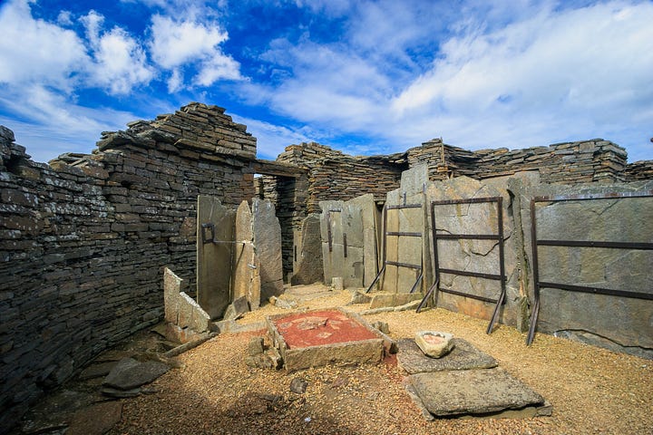
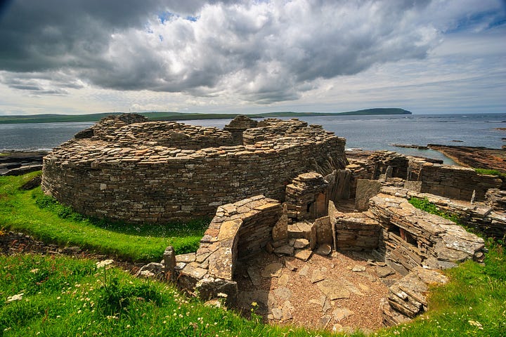
Mid Howe Broch was occupied during the Iron Age, from about 200 BCE to 200 CE. Constructed from the local sandstone, which readily splits into slabs, it is remarkably well preserved with partition walls, cupboards and fireplaces. Archaeologists found evidence of bronze working, wool spinning and grain grinding, providing some insight into the lives of the inhabitants.
It was built a short distance from Mid Howe Chambered Cairn, which is 3,500 years older. The longest and largest in Orkney, it was covered with a roof after being excavated in 1932. From a suspended walkway you can view the chambers, delineated by sandstone slabs, and look down on the 12 compartments where the dead were buried. The remains of 25 Neolithic bodies were found here, as well as the bones of many species of bird and animal that they farmed or hunted.
Within a mile’s walk you can also see ruins of a Viking hall, St Mary’s Church and 18th century farmsteads. These structures and a wealth of other chambered cairns have earned Rousay the nickname, ‘Egypt of the north’.
2. Priory Doocot
Also shaped like a beehive, this whitewashed tower has pigeon holes and a surprise inside
A. Crail and Fife Ness
Situated in Crail, at the top of the park curving around Roome Bay, the Priory Doocot, is well worth a look inside. Shaped like a windmill, it housed pigeons kept for meat. When you open the door there is a flurry of wings and cooing noises. It appears that the pigeon holes lining the inside of the tower are still occupied, but a closer look reveals that the birds are stuffed and you have been conned by clever sound effects.
At the centre of the ancient Royal Burgh of Crail stands the Tolbooth, built in 1598 as the gaol and town hall. Crail Museum and Heritage Centre is housed in the old building next door, while Marketgate was once the site of one of the largest markets in medieval Europe. The harbour was a centre of the white fish and herring industry, but now the boats bring in crab, lobster and other shellfish.
The Outstanding Walks Scotland route starting in Crail rounds Fife Ness, the headland at the tip of the East Neuk, following the Fife Coastal Path, a long-distance trail around Fife, which is bounded by sea on three sides. It returns from Kingsbarns along the course of the disused Anstruther to St Andrews railway.
3. Crested tit
Sporting a mohican hairstyle, this bird hangs out in the woods, often upside down
C. Loch an Eilein
Loch an Eilein is one of the jewels of the Cairngorms: a magical loch with a ruined, island-set castle, deep within the heart of an ancient pine forest. It lies at the heart of Rothiemurchus, an estate that has been under the stewardship of the Grant family since the 16th century. The area is steeped in history and rich in wildlife, with red squirrels and Scottish crossbills as well as the rare crested tit.
This small, fairly monochrome tit has a black collar and a stripe that extends from each eye and curls around the cheek. Its most distinctive feature is a black and white crest, which can appear extended or flattened back. The species only breeds in pine woods the UK. While feeding, they cling to trunks and hang from branches, while searching for a wide range of insects and pine seeds. The females excavate a nest in dead wood, which is then lined with moss, lichen, hair or cobwebs before the eggs are laid.
The name Loch an Eilein means ‘loch of the island’. Historians believe that the island castle was first built by the Bishop of Moray in the late 1200s and extended by Alexander Stewart, the notorious Wolf of Badenoch, in the 1380s.
4. Cocoa Mountain
What to choose – champagne truffles, a classic milk collection, or dark chocolate gingers?
B. Balnakeil Bay and Faraid Head
Faraid Head points northwards from Durness, just east of Cape Wrath, the north-west tip of Scotland. With its one mile of pristine sand, Balnakeil Bay stretches down its west side. The base of the peninsula is low-lying grassland, and its middle part contains some of the finest sand dunes in the Highlands. In the north and east it rises to impressive cliffs with several sea stacks. The highest point is inaccessible, as it is occupied by Ministry of Defence buildings used to monitor naval gunnery and aerial bombardment exercises in the sea off Cape Wrath.
The Outstanding Walks Scotland route loops south into Durness village and returns past Balnakeil Craft Village, which is housed in an unusual collection of buildings. They originated in the mid 1950s as an MOD early warning station in the event of nuclear attack. The station was never commissioned and in 1964 the site was handed over to the council, who rented out the buildings until, in 1980, the properties were sold to the sitting tenants. It is currently home to a range of local artists and businesses, with much to explore: art galleries, paintings and prints, ceramics, woodwork, glass work and the delicious chocolates of Cocoa Mountain.
5. Lady’s Tower
A stone bathing house for Lady Janet to go skinny dipping out of sight of the peasants
C. Elie, Earlsferry and Kilconquar
Two distinctive landmarks are situated on the beautiful headland of Elie Ness: Lady’s Tower, built in the 1760s as a bathing house for Lady Janet, wife of the local laird, and a little lighthouse with a castellated tower. While walking around its coast you may hear the haunting sound of ’singing’ of grey seals that are resting on rocks exposed at low tide.
Elie and the adjoining village of Earlsferry are characterised by traditional Fife architecture with whitewashed or pastel-coloured buildings, crow-stepped gables and red pantile roofs. This style is influenced by centuries of trade between Fife and the Low Countries, with roof tiles returning as ballast in ships exporting coal and salt. Now predominately a holiday destination, the harbour wall protects a sandy beach with another red sand beach beyond – Ruby Bay, so named for the gem-like garnets found on it.
Earlsferry’s name originated over a thousand years ago in events that were later fictionalised by William Shakespeare in one of his best known plays. The young MacDuff, the ‘Thane of Fife’, crossed the Firth of Forth here in 1054 while fleeing from King Macbeth. He later returned to slay Macbeth and help restore the throne to murdered King Duncan’s son Malcolm. He was rewarded by being made the Earl of Fife, and his successors later established a ferry to manage their lands on both sides of the Firth of Forth.
6. Loch Ness Monster
Legend or leviathan? Better take a camera on this walk so you have proof of your sighting
A. Falls of Foyers
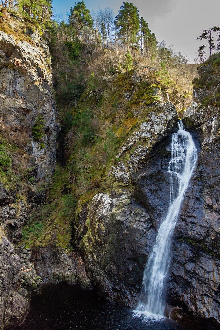
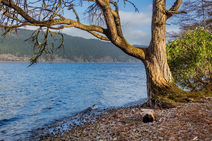
The sensational Falls of Foyers have been famed for centuries. Two high waterfalls on the River Foyers, and the impressively deep gorge they plunge into, attracted early tourists in the 18th century and became an essential visitor destination on the ‘Scottish Romantic tour’. The number of sightseers increased greatly after the railways reached Inverness in 1855, connecting day trippers to pleasure steamers that sailed up Loch Ness and landed them at Foyers pier.
In Gaelic, the Falls of Foyers are Eas na Smùide, ‘the smoking waterfall’. The upper falls tumble 46 feet (14m) over three cataracts while the more dramatic lower falls drop 98 feet (30m) down a vertiginous rock face into a dark pool.
The small village of Foyers, located on the wooded and much less visited south-eastern side of Loch Ness, is reached via the single- track B852, which follows the course of one of General Wade’s military roads. The popularity of this area is growing since the development of the 80-mile Loch Ness 360° Trail, a new long-distance walking and biking route circuiting the loch from Inverness. Sightings of the mythical ‘Nessie’ are not guaranteed!
7. Argyll's Eyeglass
One for the brave – you have to clamber through this rock window to reach the top
B. The Cobbler
The Cobbler rises above the head of Loch Long, a sea loch extending deep into the mountains, and is part of the Arrochar Alps, a range of hills named after the village below. Its three rocky summits have an unmistakable profile that is visible from miles around. A rock pinnacle on top of the central, highest peak resembles, with some imagination, a cobbler bending over his last, while the pointed southern peak is regarded as the cobbler’s wife. The overhanging cliffs of the north summit are popular with climbers.
This Corbett, a Scottish mountain between 2,500–3,000 feet (762.0– 914.4m), is fondly regarded as one of the country’s most significant hills, although lower than many other peaks. It played a major role in the development of Scottish mountaineering, being relatively accessible from the population centres of Central Scotland. As soon as the railways provided easy access in the 1890s, it was adopted by Glaswegians as a favourite excursion, and the peak has attracted walkers and rock climbers ever since.
The climb up it from the shore follows a well-made path alongside a mountain stream. Few walkers ascend the rock pinnacle that is the true summit, as that involves crawling through a hole known as ‘Argyll’s Eyeglass’ to a sloping ledge above an enormous drop before scrambling to the top ... and then safely reversing this manoeuvre. No wonder it was a test of manhood for prospective Campbell chiefs!
8. Temple Wood stone circle
5000 years ago Neolithic people chose this site for rituals and ceremonies we can only imagine
B. Kilmartin Glen
Situated in Argyll, between Oban and Lochgilphead, Kilmartin Glen has the greatest concentration of prehistoric rock art and Neolithic and Bronze Age remains in mainland Scotland. This beautiful valley has been inhabited for 12,000 years, since glaciation receded at the end of the last Ice Age. More than 800 ancient monuments have been found within a six-mile radius of Kilmartin village, 150 of them prehistoric.
Temple Wood contains two stone circles, whose construction began 5,000 years ago. The circles were in use for more than 2,000 years and reshaped in that time, with a burial cist added to the centre of the larger one.
As well as the stone circles, the walk around the glen encompasses standing stones, cup and ring marks and a ‘linear cemetery’ of burial cairns. It first visits Kilmartin Church, where over 20 medieval sculptured stones are displayed in the graveyard, many within a covered burial aisle. Next door is the recently redeveloped Kilmartin Museum, one of the key attractions on Scotland’s west coast. The museum is the custodian of many artefacts found in Kilmartin Glen and a must-visit venue, either before or after the walk, not least for its café.
9. The Virgin Martyrs’ Monument
The only sin of Margaret and Agnes was being Covenanters – for which they were drowned
C. Stirling Castle and Gowan Hill
The Virgin Martyrs' Monument was created in 1859 and is located in Stirling Old Town cemetery, although this is nowhere near Wigton, in Dumfries and Galloway, where the deaths occurred long before. The memorial has a despairing guardian angel standing over Margaret Wilson, who is reading the bible to her younger sister Agnes.
Both were arrested, along with an older woman Margaret McLauchlan, in 1685 for being followers of the Covenanters, an extreme Presbyterian group strongly opposed to the Anglican reforms of Charles II. All three were sentenced to death by being tied to stakes on the shore and drowned by the incoming tide. Their father managed to buy 13-year-old Agnes’s release, but 18-year-old Margaret and her 60-year-old friend were killed, despite a reprieve having been signed.
Stirling Castle rises above the cemetery, both of which are situated on a volcanic crag in the centre of the city. The site had been fortified since prehistoric times, but the castle’s importance peaked in the 1500s when it became the favourite residence of the Stuart kings and queens. Most of its grand buildings were built during that century. Beyond lies Gowan Hill with its Beheading Stone – used to execute prisoners.
10. Black Linn waterfall
White water, jagged rocks, roaring water and drenching spray – all add to the experience
B. Dunkeld, The Hermitage and Birnam
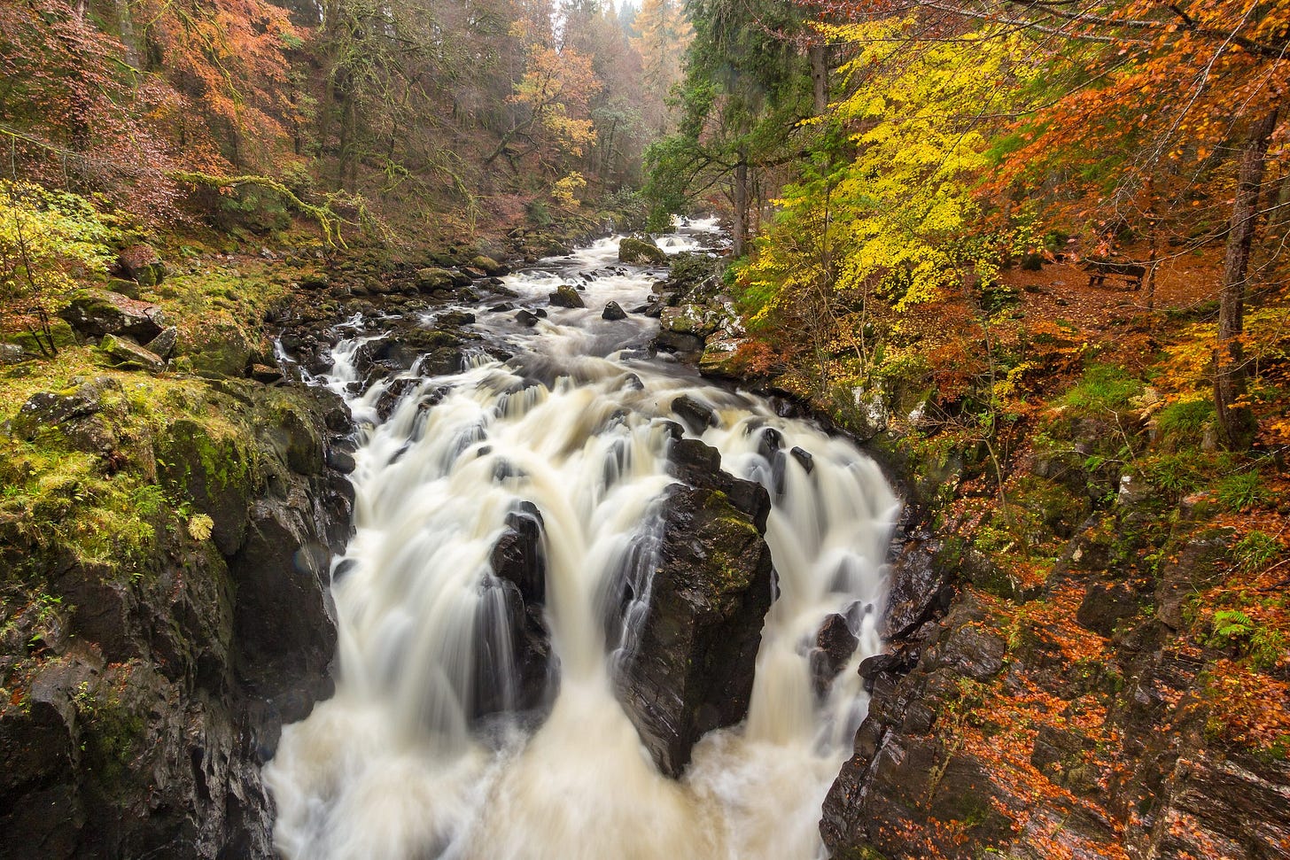
The historic village of Dunkeld, once the religious capital of Scotland, stands on the north bank of the mighty River Tay, with the Victorian settlement of Birnam on the opposite bank. It is situated in Perthshire, just north of the Highland Boundary Fault, where wooded hills rise on all sides.
During the 18th and 19th centuries, the Dukes of Atholl introduced many non-native tree species to Perthshire, with their newly-discovered Douglas firs now soaring giants at The Hermitage. This popular tourist spot is now in the care of the National Trust for Scotland.
The walk around The Hermitage follows the River Braan upstream and visits two follies. Ossian’s Hall was built in 1757 as the focal point for woodland walks. Designed to impress visitors, it has been restored to recreate the original surprise and awe felt when a sliding panel reveals a hall of mirrors that reflect the foaming waterfall surging over black rocks just below the balcony. A little further on, Ossian’s Cave, which looks like a stone igloo, is where a local was paid to live as a ‘hermit’ for the fascination of guests.
11. Madonna and Child statue
A breezy spot, but at least the infant and mother can enjoy a great view
A. Heabhal, Barra
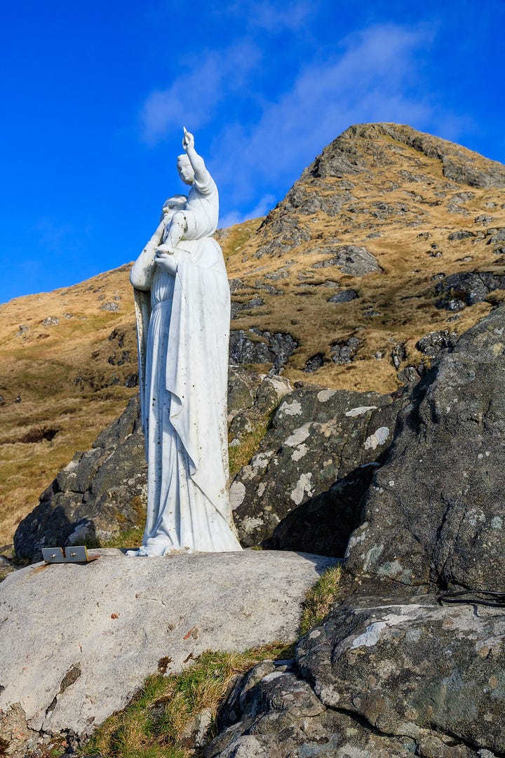
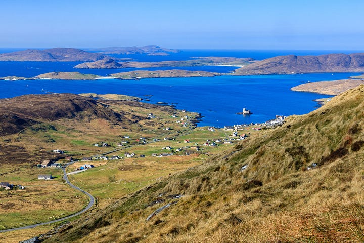
Heabhal (Heaval), Barra (Barraigh)'s highest hill, overlooks the island’s main village Castlebay (Bàgh a’ Chaisteil), where the ferry from Oban arrives, sailing past Kisimul Castle, which stands on an island in the bay. On the hill’s shoulder a white marble statue of the Madonna and Child, known locally as Our Lady of the Sea, was erected in 1954.
A climb past the statue to the summit is rewarded by one of the finest views in the Outer Hebrides, with the curving bay below and the Bishop Islands floating in the sea to the south. Barra lies at the south end of the chain of the Outer Hebrides. Only one other island further south is now inhabited – Vatersay, which was linked to Barra by a causeway, opened in 1991. Other more remote isles, such as Sandray ad Mingulay, were evacuated in the late 19th and early 20th centuries.
The island is named after St Barr, to whom the medieval church of Cille Bharra in Eoligarry (Eòlaigearraidh) is dedicated. That ancient religious site dates back to the 600s, when Christianity was introduced by Irish missionaries.
12. Moine Thrust
A fault line that puzzled geologists, because old rocks lie on top of younger ones
C. Knockan Crag
Knockan Crag National Nature Reserve is set in the astounding landscape of Coigach and Assynt, where primeval-looking mountains rise above bare moorland and scattered lochs. It is part of North West Highlands Geopark – where NatureScot “guarantee you an earth-moving experience”.
This area has some of the world’s oldest rocks, and the Rock Room and waymarked trails interpret the geology of the Moine Thrust, a major fault visible here. On one exposed rock face you can place your two hands on seams that are 500 million years apart in age. What puzzled geologists for decades – and caused heated debate – was that ancient rocks devoid fossils were lying on top of rocks formed from marine mud containing sea creatures. Eventually two geologists, Peach and Horne, used what they found here to work out the theory of continental drift, realising that the force of meeting plates had thrust older rocks on top of younger ones.
It’s a great place to stop for a picnic or to admire the amazing views and intriguing sculptures. The Thrust Trail takes you from the Rock Room to the Moine Thrust. While the steep Crag Top Trail continues upwards for wonderful views across Coigach and Assynt.
13. Lion’s Face
You’ll have to squint to see this rough, orange-coloured rock animate into a wild creature
B. Braemar and Creag Choinnich
Lying on the eastern side of Cairngorms National Park, the handsome resort village of Braemar is a wonderful centre for walking. From Creag Choinnich, the lower of the two hills that can be climbed directly from the village, you look down on Braemar and the broad valley of the River Dee, across to higher Morrone and all around to many more peaks. The summit of heather and rock rises above the lovely pine woodland that skirts its lower slopes.
If the steep climb to the 1,765-foot (538-m) hilltop is too strenuous, you can omit it but still enjoy a fine panorama from the Cromlins viewpoint while circuiting the hill. The route passes the foot of Lion’s Face, a crag of golden-coloured rock that resembles a lion, especially when seen from Invercauld Castle on the opposite side of the Dee.
As far back as the tenth century, King Kenneth MacAlpin came here to hunt, beginning a tradition for visiting Braemar that has been followed by many monarchs since, giving rise to the name ‘Royal Deeside’. As well as being close to Balmoral, this walk passes two castles: ruined Kindrochit Castle at the start, and Braemar Castle, open seasonally, on the banks of the Dee.
14. Bruce’s Stone
A weighty memorial “In Loyal Remembrance” of Robert, King of Scots
B. Loch Trool
The circuit of Loch Trool is arguably the finest short walk in Dumfries and Galloway. For a modest distance and moderate effort, you can enjoy the most outstanding views across the water to the surrounding peaks. The loch lies at the heart of Galloway Forest Park – established in 1947 – with the highest hill in southern Scotland, Merrick, rising on the north side. Along the south shore, the route follows the Southern Upland Way.
The area around Loch Trool is associated with some of the most momentous events in Scottish history. A short distance from the start is the Martyr’s Tomb, marking the place where six Covenanters (more persecuted members of the 17th-century Scottish Presbyterian and political movement) were executed in 1685. The route later passes the site of a battle between the Scots and English in 1307 and Bruce’s Stone, a large granite boulder erected in 1929 to commemorate Robert the Bruce’s victory in that battle
The Battle of Trool was the first action in the long campaign Bruce fought before securing the crown of an independent Scotland. With only 300 men, he defeated an English army of 1,500 cavalry by ambush. He lured the army along the steep south shore of the loch, then rolled boulders onto them from the crags above, knocking them into the water.
15. Tall Ship Glenlee
Built to transport cargo, this vessel once served as a sail training ship for the Spanish navy
A. Glasgow’s West End
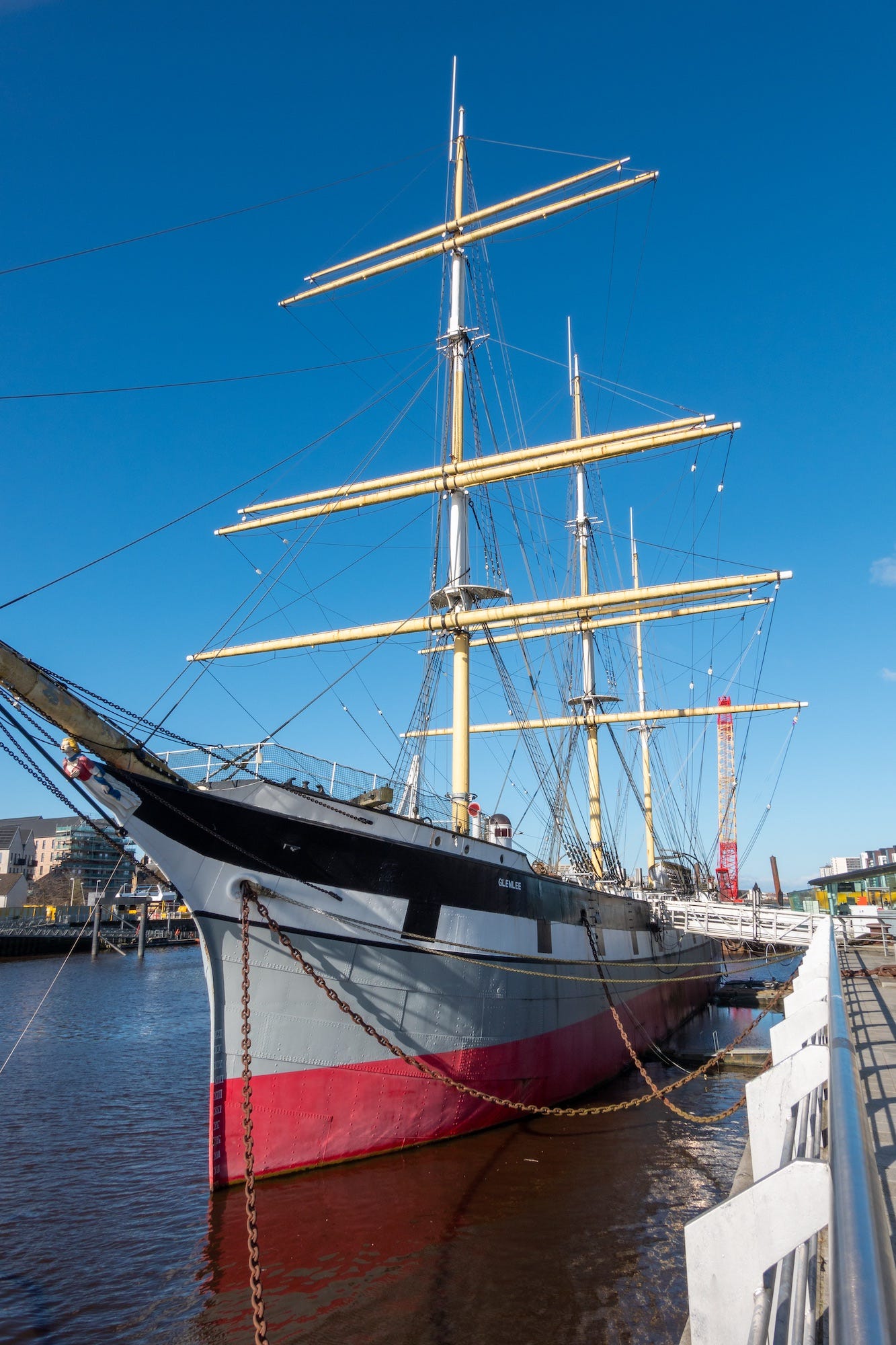
The hyper-modern Riverside Museum is situated where the River Kelvin flows into the River Clyde in Glasgow’s West End. The museum has collections of historic vehicles and state-of-the-art interactive displays, while the Tall Ship Glenlee is moored beside it; both offer free entry. Adjacent piers are used by companies offering watersports and powerboat trips.
Glasgow, Scotland’s largest city and Britain’s third largest, is known affectionately as the 'Dear Green Place’. Despite its growth being driven by shipping and commerce, it has retained dozens of parks and gardens. This walk explores the most iconic of these, Kelvingrove Park, starting from the Clyde, the hub of the city’s booming international trade in the 18th and 19th centuries.
It follows mainly foot and cycle paths around many of Glasgow’s major attractions, which encompass wildly contrasting architectural styles, from the ornate classical stone buildings of Kelvingrove Art Gallery and Museum, and the University of Glasgow, to the dazzling modern buildings of the Scottish Event Campus (SEC) and the Riverside Museum.
This link is to my affiliate page on bookshop.org via which I receive a commission for sales of books.


Lovely photos :-)
I once climbed the Cobbler, but I didn't tackle Argyll's Eyeglass - way too vertiginous for me!